


James Clerke Maxwell (1831-1879) was an interesting character. His first paper to the Edinburgh Royal Society “On the Description of Oval Curves, and those having a plurality of Foci” was written when he was only 14 and had to be read out for him because he was too young. It was based on work he had done using twine, pins and a pencil.
Besides his famous work on Electromagnetic theory, he was a leading contributor to the kinetic theory in gases and to the theory of colour vision. He correctly discovered how we perceive colour and took the first colour photograph, an image of of a Tartan Ribbon in 1861 using 3 coloured filters, red, green and blue to capture and later project 3 copies of the image.


Moving upwards from the ground the layers which are differentiated by the variation of temperature with height are:
Troposphere: From the ground continuing up to between 7 km at the poles and 17 km at the equator with some variation due to weather. It is the thinnest but most dense layer, with 72% of the total mass of the atmosphere is below 10 000m.
The troposphere is well mixed mixing due to solar heating at the surface. This heating warms air masses near the ground, which then rise as thermals. On average, temperature decreases with height.
Stratosphere: This extends from the top of the troposphere (7–17 km) up to around 50 km. In the stratosphere temperature increases with height.
Mesosphere: This extends from about 50 km to around 80-85 km. Temperature decreases with height.
Thermosphere: This extends from 80–85 km to in excess of 600km. The temperature increases with height. The Thermosphere is the boundary of the atmosphere, beyond the Thermosphere is the Exosphere, which extends into space.
The boundaries between the layers are the tropopause, the stratopause, the mesopause and the thermopause.


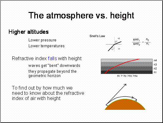
Willebrord Snel van Royen (1580–1626) was a Dutch astronomer and mathematician and is most famous for his law of refraction now known as Snell's law.
In 1617 he reported on an experiment to measure the distance between Alkmaar and Bergen op Zoom which are separated by one degree with the aim of determining the radius of the Earth.
He measured one degree to be equal to 107.4 km. which was only 3km out. He also developed new method for calculating π. He discovered his law of refraction in 1621.
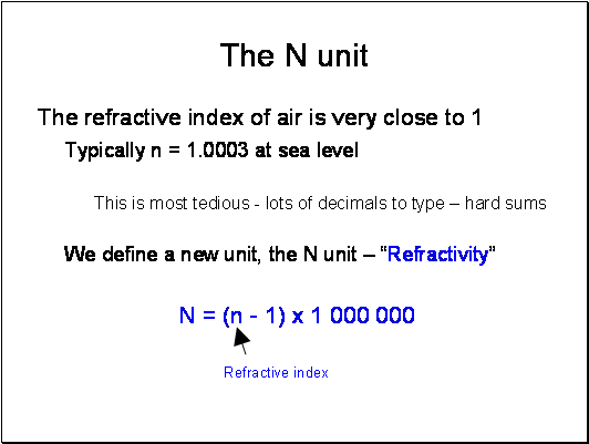

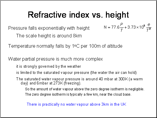
The scale height is the height where the pressure is 1/eth of the ground value. (This value of e is not the water vapour pressure, it is the constant e from natural logs and has the value 2.718). Scale heights are used frequently in describing functions that decrease exponentially.
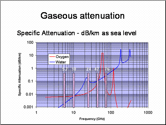
Because the water vapour pressure is governed by the amount of moisture the air can hold, once the temperature drops below 0C the water vapour condenses out as clouds. Practically, we can say the amount of water vapour above 2-3km is negligible.
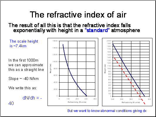
Representing an exponential function as a straight line is cheating, but it is a good enough approximation up to 1000m or so. Beware of this when planning systems on top of mountains.

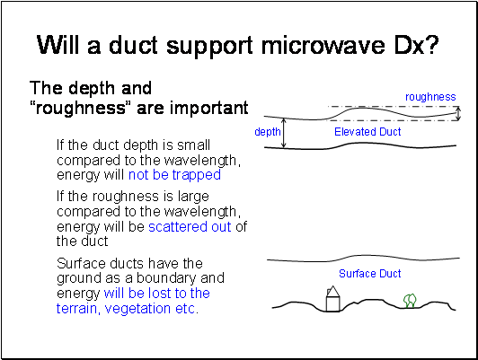
The significance of elevated ducts is that they can allow signals to propagate for very long distances over the horizon. It is possible for intermediate terminals to be below the elevated duct and not able to couple into it – resulting in non-monotonic path loss with range.

Evaporation Ducts
There is usually a region for a few metres above the surface of the sea where the water vapour pressure is high due to evaporation. This also occurs over large bodies of water, for example the great lakes. The thickness of the duct varies with temperature of the location, typically 5m in the North sea, 10-15m in the Mediterranean and often much more over warm seas as in the Caribbean and Gulf. Naturally, these ducts have a significant effect on Shipping and have been extensively researched. It is the reason that VHF/UHF propagation over sea can extend to great distances causing all sorts of international frequency co-ordination problems.
Temperature Inversions
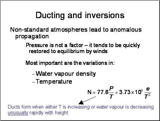
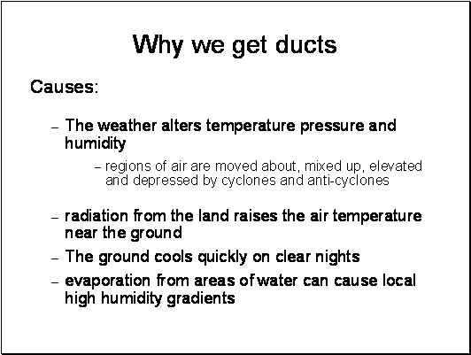
Usually, temperature falls with height by about 1K per 100m. On clear nights the ground cools quickly and this can result in a temperature inversion, where the air temperature rises with height. If it is dry, the temperature term is dominant in Equation 5 and super refraction and ducting can occur. This is particularly common in desert regions.
If there is significant water vapour the relative humidity can quickly rise to 100% and vapour condenses out as fog. This condensation reduces the water vapour density near the ground leading to cold dry air near the ground, warmer moister air above and results in sub-refraction. This can lead to multipath on otherwise apparently perfectly good line of sight links.
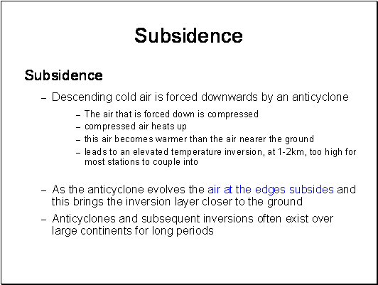
Subsidence
This is a mechanism that can lead to elevated ducts and is associated with high pressure weather systems - anticyclones. Descending cold air forced downwards by the anticyclone heats up as it is compressed and becomes warmer than the air nearer the ground leading to an elevated temperature inversion. (Atmospheric pressure always increases closer to the ground). This all happens around 1-2km above the ground far too high to cause ducting except for very highly elevated stations as the coupling angle into the duct is too great for a ground based station. As the anticyclone evolves the air at the edges subsides and this brings the inversion layer closer to the ground. A similar descending effect happens at night. In general, the inversion layer is lowest close to the edge of the anticyclone and highest in the middle. Anticyclones and subsequent inversions often exist over large continents for long periods.
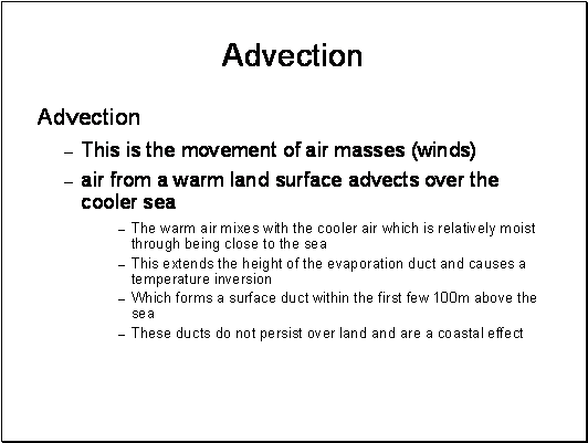
Advection
This is the movement of air masses, typically occurring in Early evenings in the summer with air from a warm land surface advecting over the cooler sea. This warm air mixes with the cooler air which is relatively moist through being close to the surface of the sea. This leads extending the height of the evaporation duct and to high humidity gradients and a temperature inversion forming a surface duct within the first few 100m above the sea. These ducts do not persist over land and are a coastal effect. Typically in the UK they are associated with warm anticyclonic weather over the continent of Europe and advection out over the north sea. They tend to be weaker than subsidence ducts but do occur relatively often over the North Sea and can persist for many days. For example, it is relatively common for UHF signals to propagate well beyond line of sight from the East coast of England across the North Sea to the low countries.
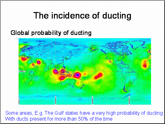
This map is from the latest ITU-R recommendations. It replaces an earlier model that only used Latitude.
This really does still need to be tested some more as it may be more of a reflection of Matlab plotting routines for sparse data than actual reality. Use with care.
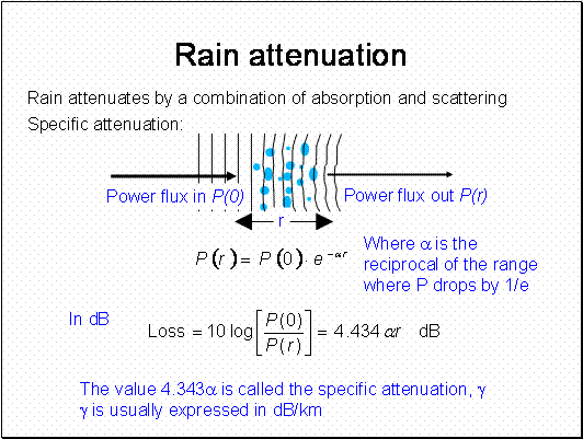
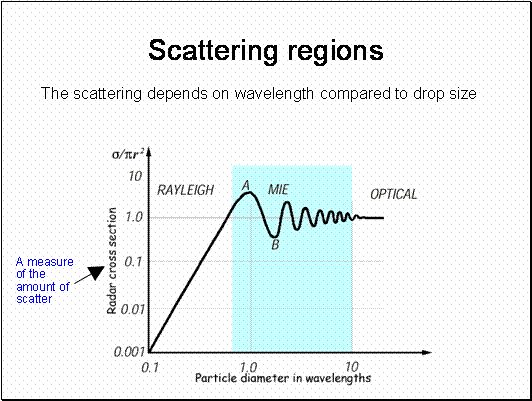


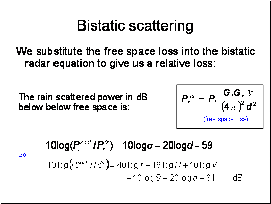
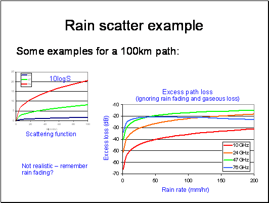
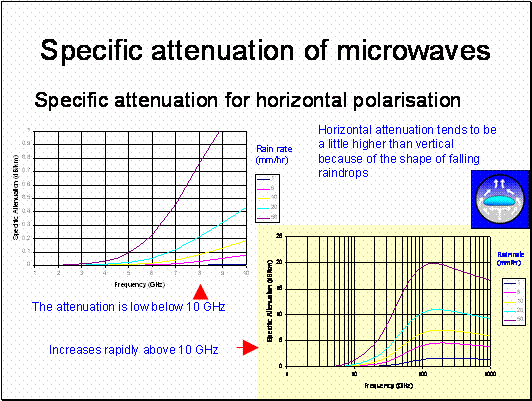
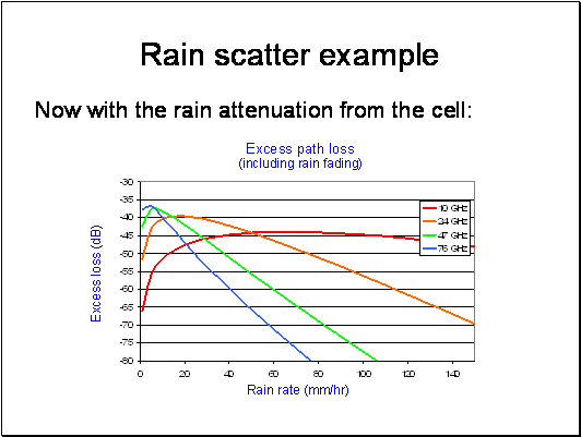
To do it properly we need to integrate the rain contribution over all space – this has to be done numerically – hence the approximations to follow


Remember that the energy in a radiowave is quantified into discrete packets of energy called photons - wave/partial duality etc. The energy of the photon is related to the frequency of oscillation e = hf, where h is Plank's constant. When considering the scattering of high frequency radiowaves, it is often more convenient to think in terms of photons.
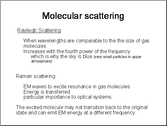
Rayleigh Scattering: When photons are of wavelengths comparable to the the size of gas molecules, scattering occurs. The most common mode of scattering is elastic scattering where energy is not transferred from the photon to the molecule. This type of scattering is called Rayleigh scattering. This scattering increases with the fourth power of the frequency, which incidentally is why the sky is blue.
Raman scattering: It is also possible for photons to interact with gas molecules in an inelastic manner so that energy is transferred between the photon and the molecule. This is called Raman scattering and this is of particular importance to optical communications systems.
At higher photon energies incident photons can excite vibrational modes polarised molecules. This is an energy transfer process with the resultant emission of a scattered photon of lower energy (i.e. lower frequency/higher wavelength) and leaving the molecule in a higher energy vibrational mode. Only certain vibrational mode energies are allowed and by inference, only discrete frequency/wavelength differences can occur. The spectra of the resultant scattered photons forms a set of spectral lines at discrete offsets from the original frequency/wavelength called "Stokes lines". It is also possible for a molecule to give up some of its energy to an incident photon and thereby increase the photon energy. Again, this forms a discrete set of lines, the "anti-Stokes lines".

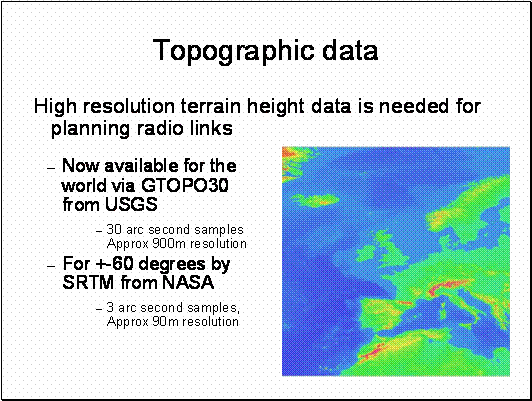
These datasets are large – They come on multiple DVDs.
The best free data can be obtained from the Shuttle Radar Topography Mission (SRTM) webpag, http://srtm.usgs.gov/ . The SRTM was a joint project between the National Geospatial-Intelligence Agency (NGA) and the National Aeronautics and Space Administration (NASA).
The data was collected over a 1 arc second grid for all land areas between 60° north and 56° south latitude. For various reasons, mostly to do with “defence” global data is only available at 3 arc second resolution – but this is available for free. This is very different to OSGB data which, although better resolution is expensive and subject to strict licensing conditions.